QI
Materials Advancing Abundant and Renewable Natural Hydrogen Assets
Significant natural hydrogen discovery at
Ville Marie Hydrogen Project in Quebec; QI Materials has
outlined a highly charged 80km2 natural hydrogen area -- extraordinary in
potential.
"The
300km2 Ville Marie project is seeping white
hydrogen at surface with intensity;
e.g. soil samples returned hydrogen
concentrations over 1000ppm on its 9.7km North-South Line -- CSE:QIMC presents exceptional opportunity
as a world-class natural hydrogen district
camp in the making."
-- Market Equities
Research Group
------
------ ------
------ ------ ------
Click to listen to CEO's
October 24, 2024 corporate update on recent H2 exploration
efforts
Valuation Commentary:
Québec Innovative Materials Corp. (CSE: QIMC)
(Frankfurt: 7FJ)(US Listing: QIMCF) (a.k.a. QI Materials) is a Canadian-based
mineral exploration and development company focused on specializing
in the exploration of white (natural) hydrogen and high-grade silica
deposits. QIMC aims to unlock the full potential of these materials
to drive forward clean energy solutions to power the AI and
carbon-neutral economy and contribute to a more sustainable future. QI Materials is included in the NHV
Nat H2 Index, the first Natural Hydrogen Index.
QI Materials is now the most advanced
natural hydrogen project in Canada and arguably among the top two of
all North America in terms of natural renewable hydrogen. QI
Materials is now at the stage where it is actively detecting the
reservoirs and main vectors of transmission of the natural hydrogen. The
geological team has begun advanced gravimetry and
audiomagnetotellurism (AMT) geophysical surveys at its Ville Marie
Natural Hydrogen Project. The gravimetry surveys focus on
assessing variations in the thickness of local sedimentary rock
deposits, known as gravity troughs, over the Archean basement. The
AMT surveys are instrumental in
locating graben-related faults. This
critical data will help identify areas most likely to contain
reservoir rocks and conduits of H2 flow. See October 24, 2024 news
release regarding the first geophysics results entitled "QIMC
Unveils Landmark Geophysical Survey Findings in its natural hydrogen
Ville Marie project"; in-short, we can clearly see the
north-south fractures that plunge down, where the sedimentary rock
is broken and fractured, creating conduits of H2 flow to be captured.
The team is currently identifying, with its
proprietary geophysical equipment and techniques, the dominant
principle fractures. These fractures will be overlaid with the soil
samples, and the high-flow north-south fractures (which are the
conduits of H2) will have gas probes installed to measure the flow
itself, and that will lead to geotechnical drilling in ~May-2025.
Big names such as Bill Gates and Jeff Bezos
have recently begun funding white hydrogen exploration start-ups to
the tune of hundreds of millions of dollars to find what QI
Materials has essentially already discovered, it is important
to appreciate just how much of a leg-up QI Materials has in terms of
prospective ground; QI Materials secured the most prospective
natural (white) hydrogen claims in the Province of Québec as
recommended by the Institut National de la Recherche Scientifique ("INRS")
following 6 years of comprehensive research (geophysical and
geochemical work including the collected thousands of C1-C4 Soil-Gas
analyses) headed by Professor
Marc Richer-LaFlèche, P.Geo. INRS is a Québec graduate research funded
university organization with one of the biggest geo-labs in Québec.
Professor Richer-LaFlèche is one of only two recognized geologists
in Canada that is both a geophysicist and a geochemist.
In-short, QI Materials hydrogen undertaking is backed by deep
science and geology. Professor Richer-LaFlèche indicated to QI
Materials which areas his model pointed, based on research papers
that had come from Australia (e.g. the successful Ramsey Hydrogen
Project which is currently valued at several times the current
market cap of QIMC), where he noticed a lot of similarities in terms
of rock type and fault systems. The INRS had developed a soil
sampling methodology for the presence of natural hydrogen and areas
of Southern Québec were scoring high. QI Materials now controls
~90% of the hydrogen showings within the province of Québec and
has partnered with the INRS to systematically reveal the enormity of
what it possesses. A major international player that has recently
staked large areas of BC using similar hydrogen bearing rock model
criteria have let it be known that Quebec was actually their first
choice of areas to stake, but QI Materials had already beat them to
the punch.
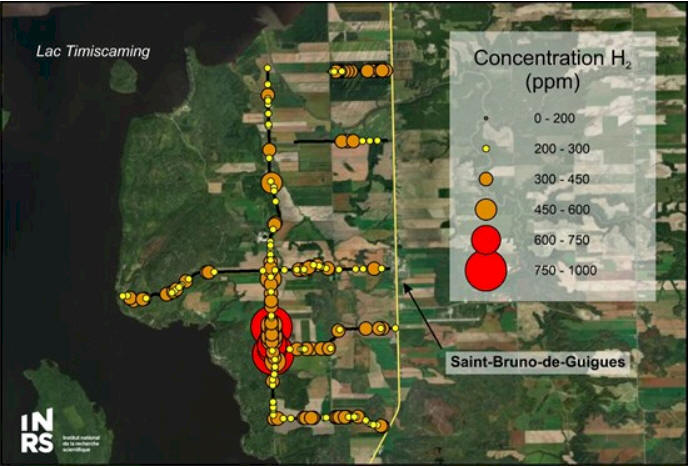
Fig. 1a (above) - Map of the distribution of
hydrogen anomalies, data projected onto satellite image
background. NOTE: 8 readings exceeding 600 ppm, with 2 of those
surpassing 1000 ppm.
QI Materials has since expanded the Ville Marie
Hydrogen Project discovery 11 kms to the northwest (see related
October 3, 2024 news), recording soil gas measurements from
Line 13 of 594, 543, and 463 ppm.
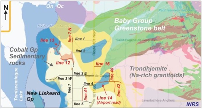
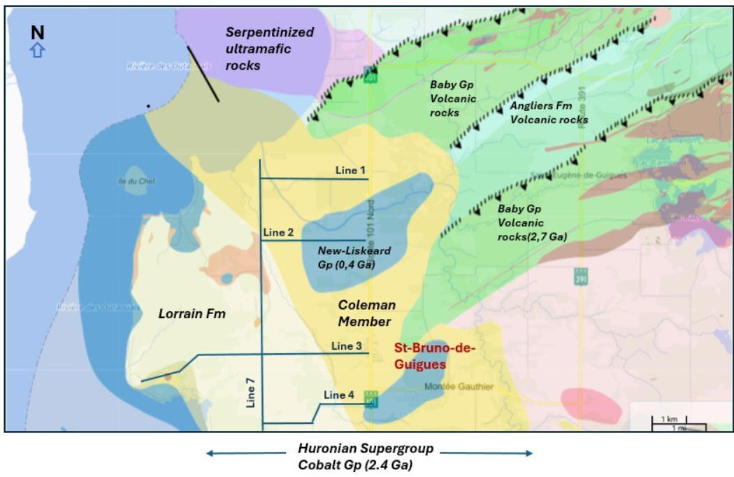
Figure 1b (Above LEFT) & 1c (above RIGHT) -
LEFT image: Location plan of the new lines of the September 2024
Soil-Gas survey (in red) and simplified geological map (modified
from SIGÉOM, MRNF) highlighting the absence of a green belt
(volcanic) in the St-Bruno-de-Guigues airport road sector. RIGHT
image:
Simplified regional map showing exploration sectors A, B and C
(newly acquired) of
the Ville-Marie project.
A world-class natural hydrogen district camp
is in the making. Now it is just a matter of understanding exactly what they have; currently at Ville Marie it
appears to be multiple secondary reservoirs that are linked to a
principal reservoir, which is the fault itself. QI Materials is
aiming to demonstrate that there is a very good chance of a
commercial hydrogen extraction -- the prospective claims are large and
remember, with natural hydrogen it generally continues to replenish
reserves, continually flowing 24/7. QI Materials will be aiming to
quantify the flow rate and the concentration of hydrogen itself,
from this they will know what volume can be extracted at what rate. This project has earmarks of enormous potential for H2
extraction that would help decarbonize industries in the region with
a lower environmental footprint than industrially produced hydrogen.
In the end this will come down to an infrastructure play by majors
that will ultimately be looking to take the project over; already QI Materials has received significant interest from major
conglomerates wanting to be kept in the loop on developments.
CSE:QIMC presents exceptional value and could easily move to be
trading, in the near-term, several multiples higher than its current
share price:
QIMC currently has a nominal market cap of only ~C$25M (~107
million shares trading near ~C$0.23). Over 50% of the shares
outstanding are held by insiders and family. Although QIMC's high-purity
silica assets are valuable on their own, it is on the
hydrogen front that QI Materials could see extraordinary near-term
gains. The shares outstanding quoted above include the recent
announcement of 9.915 million warrants having been exercised, which
also leaves the Company sufficient funds to accomplish natural hydrogen
exploration goals well into Q2-2025. The Québec government has an ambitious goal of reducing GHG
emissions by 37.5% from 1990 levels by 2030, the role of green
hydrogen initiatives feature prominently in its strategic plan.
A good comparable
for investors in QI Materials to look at is
Gold Hydrogen Ltd. which currently trades near
AUS$0.74 share on the ASX with a market capitalization ~$118
million (C$109 M as of October 25, 2024). Gold Hydrogen Ltd. is
in its early stages yet already has a substantial marketcap --
with newsflow, QI Materials has potential to ramp up significantly
in valuation near-term.
Other peer comparables are Pure Hydrogen Corp. (ASX:PH2
marketcap ~C$50M), and Hyterra Ltd. (ASX:
HYT marketcap ~C$41M) Note: Recently Fortescue acquired a
strategic interest (~40%) in Hyterra (natural hydrogen exploration
in Kansas) and shareholders experienced a sizeable shareprice jump -- as QI
Materials project moves forward, the derisking will accelerate and
QIMC will be an increasingly attractive target. What is going on now
with natural hydrogen is revolutionizing the energy space, similar
to what occurred with helium exploration and development in
Saskatchewan and Alberta (it went from nothing to a multi-billion $
industry in a few years). This is even bigger, more akin
to the early 20th century oil staking boom in Texas; astute
investors are increasingly starting to recognize QI Materials prime
natural hydrogen claims as extreme value propositions destined for
much higher valuations.
The first pass discoveries have yielded
phenomenal concentrations and purity, however this is only on a
small sliver of the 300 sq km Ville Marie Hydrogen Project. Also
important to note is that helium (He) and hydrogen (H2) are produced by the
same reactions, although the focus has been on H2 the
geological team is planning to do a systematic soil measurement of
He too. QIMC commissioned the expanded focus on H2
sampling following the discovery of H2 in high
concentrations earlier in 2024 had been made, however the prospects
of a significant He discovery run high.
QI Materials is now as much a technology
company as it is a mining/gas exploration company. The company as
has proprietary cutting-edge H2 exploration technology unique to the
head of its exploration team, Professor Richer-LaFlèche of Institut
National de la Recherche Scientifique ("INRS"). QI Materials is now
recognized as a preeminent leader in natural H2 exploration and will
be the focus of significant attention at the upcoming
Reuters Hydrogen Conference in Huston December 4 -5, 2024.
Besides ongoing news flow from developments on
the Ville Marie Hydrogen Project, QI Materials' INRS hydrogen
exploration program on its highly prospective Lac St. Jean Hydrogen
Project is set to begin in November-2024; since IRNS also
recommended the acquisition of St. Jean based on research findings
over the last six years, another home-run could be on tap near-term.
Plus there is the Gaspe Bay Hydrogen Project to be tested. Below we provide an overview of each project.
NOTE: The above claims map has since been
increased from 250 sq km to 300 sq km.
The areas that QI Materials is focused on are
where the greenstone plunges right under the sedimentary rocks, from
a geological standpoint that is key to what produces the natural
hydrogen at such a high degree (throughout the system, creating
essentially a valley of hydrogen), you don't find this type of
natural hydrogen anywhere else in Canada or North America.
Fig. 4 (above) -- The Temiscamingue graben area is severely affected by
seismicity and normal faulting related to extensional
processes still active today (Fig. below). Such
structures may be important in allowing the transfer of
gases from deep sources to shallow environments. For H2
and He exploration, these faults must be well located in
space (Lidar, AMT, gravity, magnetometric surveys) and
geophysical surveys must be carried out in order to
verify the vertical extension (in depth) of the faults.
The deeper these structures are, the greater the
potential for gas transfer.
Fig. 5a (above) -- The Temiscamingue graben -- QIMC and INRS have selected
the Lake Temiskaming Graben area for its unique
geological context, which marks the transition between
an Archean greenstone belt rich in ultramafic (komatiites
and peridotites) and iron formations (Baby's Gp) and the
Cobalt Group sedimentary rock basin (Proterozoic). This
transition zone is also affected by graben faults and
the emplacement of a Cretaceous kimberlite field. These
observations indicate that the area has been active for
over 2,700 million years, as evidenced by the record of
supracrustal and igneous rocks in the region. Geological
Survey of Canada aquatic seismic data from Lake
Témiscamingue show that a strong earthquake affected the
Lake Témiscamingue basin during the Quaternary, and the
very large number of epicentres recorded in the area of
Lake Kipawa (southern extension of the graben) indicates
that the graben is still a tectonically active zone.
This geological context could be favorable for the
transfer of gas from deep sources to the surface.
Starting in June 2024, INRS teams were out in the field,
taking gas samples from the soil (soil gas survey) and
conducting underwater surveys in Lake Témiscamingue.
These surveys were used, among other things, to
locate degassing zones associated with faults in the Témiscamingue rift.
Subsequently, geophysical surveys will be carried out to
detect deep structures in the rock. Drone surveys will
also be realized to provide useful remote sensing data
for hydrogen and helium exploration.
Fieldwork this Summer-2024 was carried out mainly in the Municipality
of St-Bruno-de-Guigues sector.
QI Materials Témiscamingue property
offers similar geology to the recent large natural
hydrogen Ramsey Project discovery by GoldHydrogen Ltd in
South Australia.
"The conceptual exploration
model that led to the development of the exploration
program is the hydrogen production model in the context
of Precambrian basement and more specifically the
sub-model linked to the presence of iron-rich rocks
associated Archean greenstone belt In the Témiscamingue
area and more precisely in the St-Brunode-Guigues
sector, the units of the Baby volcanic belt containing
peridotites, komatiites, basalts and iron formation.”
Furthermore, “These
sedimentary rocks, covering the Precambrian basement,
are affected by the still active Temiscamingue rift zone
(neotectonic deformations)," said Marc
Richer-LaFlèche, of the INRS who is heading the program.
Fig. 5b (left) Comparable
Back in May-2024 Mining MarketWatch Journal
provided a detailed overview of QI Material's Q2-2024 exploration
research summary program written by PR. Marc Richer-Laflèche, PHD.,
GEO on QI Material's quest for natural sources of hydrogen and
helium in the Tèmiscamingue area (QC), archived copy of the
exploration program may be viewed
here.
The following video from QI Materials shows
soil samples being taken on its Ville Marie Hydrogen Project:
Watch Quebec Innovative Materials Corp. and its Quebec partners, INRS, soil sample over 380 PPM Natural Hydrogen on its Ville Marie Property. In July, 2024 QIMC makes first significant discovery of Natural Hydrogen soil-gas anomalies in Quebec. pic.twitter.com/i8g0k9pV67
Takeaway from watching the above twitter/X
video post: Here we can see the sampling methodology. They drill
down ~80 cm, connect sampling equipment and hydrogen comes out under
positive pressure filling the sample bag. Results can be quickly
read -- no lengthy lab waits.
NO FALSE POSITIVES FOR QI MATERIALS:
Soil samples are key to any hydrogen project and false positives
need to be ruled out (something QI Materials does not have a problem
with). Some hydrogen exploration companies are looking for H2 in old
oil or gas wells and have issues with anthropogenic values where
the corrosion of wells create hydrogen. Other hydrogen exploration
companies have false positives coming from bio generation caused by
the soil type whereby bacteria could break up and produce hydrogen.
In QI Materials case hydrogen comes up from the fault via the
water coming up from the fault, which geochemically reacts to the
specific type of basement rock that is rich in iron, potassium,
radon, etc... that geochemical reaction takes out the "O" from the
H20 and that is where the hydrogen seeps from.
Where do we sit now in terms of the
exploration model steps?
INRS/QIMC is methodically going through four key
modeling steps;
The sourcing the H2
The migration of the H2
The accumulation of the H2
The leakage of the H2
1) Source of the H2 (confirmed):
QIMC/INRS has established the source of the H2; it’s the underlying
sedimentary bedrock, deep in origin.
2) Migration of the H2: QIMC/INRS has released initial
geophysics down to 90 m on Line 1 and Line 3, see Oct. 24, 2024 news
"QIMC
Unveils Landmark Geophysical Survey Findings in its natural hydrogen
Ville Marie project". The plan is to go progressively deeper
down to ~5 km. This initial geophysics phase of exploration, to
locate migration pathways with increasingly defined imagery, will
take until ~May 2025, at which time geotechnical drilling is
expected to begin. The team has plans to eventually refine
geophysical surveys to the point they will be precisely measuring
faulting to intervals of every 20 cm.
Geophysics excerpts from the October 24, 2024
news release:
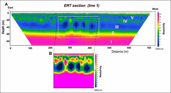
Figure 5c (above) Section Line 1 -- We
can clearly see the clay rich sediments (seen in blue in the image
between the green and the yellow) capturing the H2. The geos can
clearly see the fractures that allow the H2 to seep upwards
North-South and head East-West.
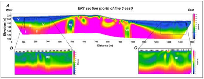
Figure 5d (above) Section Line 3 -- The anomalies are
horizontal, and we can clearly see the North-South fractures that
plunge down, where the sedimentary rock is broken and fractured,
creating conduits of H2 flow to be captured.
3) Accumulation of the H2: The hydrogen system is
dynamic, and will focus on both volume, reservoirs, and feeding
flow (which is the most important metric), this will give an
indication of the rate at which H2 may be
industrially drained.
Figure 5e (above) - Idealized model of
possible potential - This is an excerpt from a presentation
slide-deck used to help explain to laymen how hydrogen is formed,
migrates, is trapped, tapped for industrial use, and leaks.
4) Leakage of the H2: QIMC/INRS shines in its ability to
detect seepage at surface and has made the association between the
hydrogen seeps and positive thorium, radon, and potassium anomalies.
QIMC Unveils Landmark Geophysical Survey
Findings in its natural hydrogen Ville Marie
project
Quebec Innovative
Materials Corp. (CSE: QIMC) (FSE: 7FJ) ("QI
Materials", "QIMC" or the "Company"),
is proud to announce the very successful
results of the non-invasive geophysical
surveys conducted in the St-Bruno-de-Guigues
area of Témiscamingue. These surveys were
commissioned by QIMC to its partner the INRS
following the detection of high hydrogen
soil-gas anomalies during its summer soil
sampling covering an area of 80km2.
"We are thrilled
with the outcome of these geophysical
surveys on the first 3 lines measured",
said John Karagiannidis, CEO of QIMC. "The
results are in line with our expectations
and further confirms Professor Marc Richer-Lafleche
hydrogen model of a deep seated hydrothermal
source. Even without drilling data, the
anomalies seen in the imagery along line 1
suggest a break in the clay horizon's
integrity, potentially allowing hydrogen to
migrate to the surface. Also, the
disturbances on line 3, combined with strong
hydrogen soil anomalies, point to the likely
presence of gas in the sediments. This
geophysics data provides a clear and
detailed understanding of the Quaternary
geology underlying the hydrogen anomalies
and the reservoirs. These findings are
critical for future exploration and natural
hydrogen development in our natural hydrogen
Ville Marie project, as they provide a
comprehensive understanding of the area's
geology, faulting and gas seepage dynamics
reservoir structures"
To document the characteristics of the
terrain beneath these high hydrogen soil
anomalies, QIMC partnered with the Institut
national de la recherche scientifique (INRS)
to carry out cutting-edge geoelectric
tomography (GTS). This technique allows for
the detailed mapping of subsurface
geological features without the need for
invasive stratigraphic drilling.
Surveys
The first survey (figure 1), carried out in
October 2024, involved the production of
sub-surface imagery with very high spatial
resolution (inter-electrode distance spacing
of 5 m). This will be followed, in November
2024, by a geoelectric tomography survey
with a vertical penetration of the order of
350 m (inter-electrode distance spacing of
20 m), and subsequently by an
audiomagnetotellurics (AMT) survey with high
vertical penetration of the kilometer order.
Being particularly sensitive to the presence
of electrical discontinuities associated
with faults, this method should make it
possible to locate and prioritize the
importance of faults associated with the
Témiscamingue graben. Concurrently with
these surveys, a gravity survey (50m
stations) is being currently carried out to
document regional variations in the
thickness of the sedimentary rock basin.
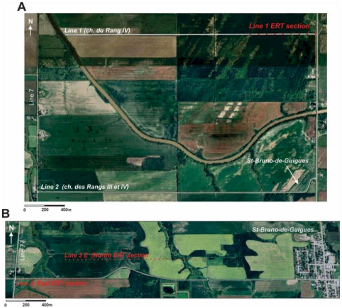
Figure 1. Line 1 survey line and line 3 East
and North survey lines
One of the objectives of INRS and QIMC is to
identify areas of maximum thickening of the
sedimentary rock sequence overlying the
Archean basement in order to identify the
most likely places for the reservoirs. This
objective should be easy to achieve, given
the difference in density between the
Proterozoic and Ordovician sedimentary rocks
and the volcanic and intrusive rocks of the
Baby Group (greenstone belt).
The data generated by the galvanic and
electromagnetic geoelectric surveys will
also be used to optimize the injection and
recording parameters for the electromagnetic
data (TDEM) to be measured in winter 2024
going into early 2025. The latter will be
acquired using a mobile ground-based system
capable of producing electrical resistivity
and electrical chargeability sections with
vertical penetration of the order of 100-200
m and horizontal resolution of the order of
15 cm. This system is essential for locating
fractures and faults masked by
glaciolacustrine deposits, and for
distinguishing Ordovician sedimentary rocks
(less resistive) from Proterozoic
sedimentary rocks (more resistive).
Geoelectric tomographic survey
The INRS team carried out a very
high-resolution geoelectrical tomography
(electrical resistivity and chargeability)
survey to produce electrical resistivity and
chargeability imagery along lines 1 and 3Est
and north of line 3E. The objectives of the
survey were to: 1) provide imagery to assess
overburden thickness variability, 2) clarify
the stratigraphy of Quaternary sediments
overlying sedimentary rocks, and 3) verify
that the strong hydrogen anomalies detected
during the Soil-Gas survey are not
associated with simple sulfide weathering
processes. "This
last point is critical", notes
Professor Marc Richer-Laflèche, head of INRS'
Applied Geoscience Laboratory, "as
the aim of the project is to locate hydrogen
anomalies originating from deep-seated
sources, rather than small local anomalies
associated with the weathering of sulphides
located at the contact between mineralized
bedrock and local groundwater."
The survey was carried out using a Terameter
LS (10 channels) and multi-connector cables.
Acquisitions were carried out in gradient
mode. Zond RS2D software was used for
quality control, data inversion and 2D
imaging.
"The results
obtained indicate that geoelectrical
tomography is an effective method that works
remarkably well in the electrically
conductive terrain of St-Bruno-de Guigues"
states Professor Richer-Laflèche. "In
the very high spatial resolution acquisition
mode, the method reveals the presence of
several sedimentary horizons in the
Quaternary sequence, and pinpoints the
position of the contact with the rocks of
the sedimentary basin."
Section Line 1
Figure 2. A) High-resolution geoelectrical
tomographic imaging of a portion of the rang
IV road (line 1: rte du 4ième rang) in
St-Bruno-de-Guigues. B) Contrast enhancement
by scaling electrical resistivity values.
Modeling and 2D data inversion: M.R.
LaFlèche).
Section along line 1
(rte du quatrième rang): This survey was
carried out in the area of the first
hydrogen anomaly discoveries (July 2024) in
the northern part of St-Bruno-de-Guigues.
The section clarifies the contact between
bedrock (between I and II) and the
Quaternary sequence, comprising some 5 units
(II: sand and gravels; III: clays; IV:
sands; V: clays and silty sands at the
top)(Fig. 2 a). "The
imagery obtained along line 1 also shows
significant heterogeneity, particularly
affecting horizon III, which according to
our model would be a low-permeability
clay-rich horizon (Fig. 2b)"
notes Professor Richer-Laflèche. "Despite
the absence of drilling in this area, we
believe that this anomalous domain marks a
break in the tightness of a clay horizon",
continues Professor Richer-Laflèche, "allowing
gases such as hydrogen to ascend to the
sub-surface and soils."
Section north of line 3E
This 1500m-long section was laid parallel to
line 3E to avoid electrical interference
associated with a transmission line located
along chemin du Quai (line 3E). Note that
the Soil-Gas survey for line 3E reported
very strong hydrogen anomalies that could
not be explained by surface observations.
"The section shows
a more complex geological and topographical
context than line 1 (Fig. 3a). In the
central part, the bedrock becomes
sub-outcropping sub-flush (I) (Lorrain Fm
sandstone) and shows more conductive
sub-vertical anisotropies, which we
interpret as major fractures that could be
important in the process of hydrogen
transfer to the surface(VI and VII)"
states Professor Richer-Laflèche. "Note
that these fractures (or faults) affect
sub-horizontally dipping sedimentary rocks.
As with the Line 1 section, it shows the
presence of sandy-gravelly (III and IV) and
silty-clay (V) sediments (Fig. 3a), which
also appear disturbed in sectors VIII and IX
(Fig. 3b and C). Despite the absence of
drilling data at present, we interpret these
disturbances as electrical resistivity
anomalies related to the probable presence
of gas in the sediments, as they are located
in an area characterized by strong hydrogen
anomalies in the soils (ref. Soil-Gas survey
on line 3 East)."
Figure 3. A) High-resolution geoelectric
tomographic imagery calculated from data
collected along a section located north of
Chemin du Quai (line 3E)in St-Bruno-de-Guigues.
B and C) Contrast enhancement by scaling
electrical resistivity values. Modeling and
2D data inversion: M.R. LaFlèche.
Probable origin of
disturbances observed in high-resolution ERT
imagery
The presence of sub-vertical electrical
resistivity anisotropies, affecting
glaciolacustrine sediments, could be
explained by different geological processes.
Given the seismic context of the region, the
increase in electrical resistivity values in
silty clays could be explained, among other
things, by the emplacement of non-cohesive
sand dykes in cohesive silty-clay sediments.
In fact, an earthquake-related sand eruption
was observed in the Témiscamingue graben
Northeast of New Liskeard (Doughty et al.,
2010). "We believe
that the presence of sub-vertical sandy
dykes (more porous and permeable) could
promote the ascent of hydrogen through the
clay-silt cover (impermeable) and thus
produce hydrogen anomalies in the soils."
states Professor Richer-Lafèche. "Also,
locally, if the gas flow is significant (advective
flux sectors), subvertical resistive
anomalies could be linked to the presence of
significant quantities of gas, thus
explaining a localized increase in
electrical resistivity values."
This will be further confirmed by
geotechnical drilling planned for Spring
2025.
"Deeper data,
located in the sandstone horizon of the
Lorrain Formation (Cobalt Gp), suggest that
despite the sub horizontal nature of the
stratification of the sandstone units, these
rocks appear fractured and probably
faulted," notes Professor Richer-Laflèche.
"This is underlined
by a sharp drop in electrical resistivity
values. This type of rock discontinuity
could be an exploration vector for advective
gas flow zones in Proterozoic, Ordovician
and Silurian sedimentary rocks of the
Témiscamingue graben."
"The successful
results of these surveys mark a significant
step forward in QIMC's efforts to explore
and harness Ville Marie's natural hydrogen
resources in a responsible and sustainable
manner." continues John
Karagiannidis, president of QIMC. The data
collected from the geophysical surveys will
be further analyzed and integrated into
QIMC's ongoing exploration strategy for the
region, ensuring that future developments
are grounded in sound geological
understanding.
QIMC will continue to engage with local
stakeholders and provide updates as the
project progresses. The company is committed
to maintaining transparency and fostering
positive relationships with the community
throughout this process.
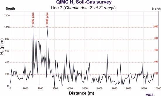
QIMC Announces Landmark Discovery of
Hydrogen Soil Samples over 1000ppm on
Recently Completed 9.7km North-South Line,
Outlining Highly Charged 70km2 Hydrogen Area
Quebec Innovative
Materials Corp. (CSE: QIMC) (FSE: 7FJ) ("QI
Materials", "QIMC" or the "Company"), is
proud to announce a landmark discovery made
in collaboration with our Quebec partner,
the Institut National de la Recherche
Scientifique (INRS). The findings from the
recently completed 9.7km north-south line 7
have uncovered hydrogen soil samples with
concentrations exceeding 1000 parts per
million (ppm). Significantly, we observed 8
readings exceeding 600 ppm, with 2 of those
surpassing 1000 ppm. Additionally, the
average measured 531.9 ppm over a 450 ms
interval between the readings above 1000 ppm
(Fig. 1). Professor Marc Richer-Laflèche,
Scientific Head of Applied Geoscience
Laboratory comments, "These
highly anomalous values can be considered
first-class given the absolute values that,
locally, exceed the instrumental detection
limit of 1000 ppm. The results from Line 7
validate the geological hydrogen model
interpretations we outlined in previous
announcements."
The data distribution is illustrated in
Figure 2, which maps the anomalies against a
backdrop of satellite imagery.
Figure 1. Section showing the variability of
H2 concentrations measured in the soils of
line 7 at St-Bruno-de-Guigues. Data are
given as a function of distance in meters
"We are thrilled to
announce this transformative discovery
outlining a highly charged 70km2 hydrogen
area within our 250km2 Ville Marie property,"
said John Karagiannidis, CEO of QIMC. "The
hydrogen concentrations identified by INRS
mark a significant advancement in our
pursuit of clean, renewable energy
solutions. This breakthrough highlights our
leadership in the hydrogen sector and
strengthens our commitment to advancing
sustainable technologies that support
Quebec's clean emission goals. We eagerly
anticipate the next steps in developing and
commercializing this remarkable hydrogen
resource."
Strategic Impact
To delineate the area of high hydrogen
values observed along line 1 of the July
2024 soil gas survey, the INRS field crew
extended line 1 westward during the first
week of August 2024. This extension begins
at the boundary between forest and
agricultural land and ends near the chemin
des secondes et troisième rangs of
St-Bruno-de-Guigues (line 7). "As
initially predicted in our hydrogen model,
the intensity of the soil hydrogen anomalies
gradually decreased towards the west (Figure
3)", notes Professor Marc Richer-Lafleche.
"This decrease in
concentration emphasizes a westward closure
of the hydrogen anomaly domain. This spatial
variability may reflect, among other things,
the presence of contrasting geological units
(arkosic sandstones, Cobalt Group
conglomerates, Ordovician dolomitic
limestones) and also the probable presence
of the Rivière-Blanche fault, which may be
present in the St-Bruno-de-Guigues area
beneath the thick glacial-lacustrine
sediments", states Professor Marc
Richer-Lafleche.
Fig. 3: Location map of the soil gas survey
for Line 7 (North-South) and East-West Lines
1, 2, 3, 4 and 5.
"We
believe that this fault is partly
responsible for the emplacement of hydrogen
in the St-Bruno-de-Guigues area,"
said John Karagiannidis, CEO of QIMC. The
location of this fault is a priority for
QIMC and INRS and will be the subject of a
high spatial resolution audiomagnetotelluric
survey to be carried out in the fall of
2024.
"In the area of the
sampling stations containing the hydrogen
anomalies, there is no evidence in the field
(or in the MRNF databases) of the presence
of wells (former mining or oil wells), which
could explain, among other things, the
presence of H2 anomalies from anthropogenic
sources. What's more, unlike the false H2
anomalies regularly reported in the
scientific literature, the H2 anomalous
zones at St-Bruno-de-Guigues extend for more
than one kilometer (along north-south or
east-west axes), which cannot be explained
by anthropogenic sources.
It is also unlikely that the gas anomalies
are the result of subsurface biogenic
processes, as the glaciolacustrine sediments
hosting the H2 anomalies and also the
H2-depleted zones (background) are very
similar from one sampling site to another.
These Quaternary sediments are essentially
dominated by a mineral matrix with little
potential to generate significant amounts of
hydrogen through fermentation reactions with
organic matter. In contrast to the study by
Etiope et al. (2024), which was carried out
on soils from the Pusteria Valley region
(northern Italy), the H2 concentrations
observed in soils from the Lake
Témiscamingue graben are not associated with
very high CH4 and CO2 concentrations.
Therefore, it is likely that the source of
hydrogen in St-Bruno-de-Guigues soils is
geological rather than biogenic,"
details Professor Marc Richer-Lafleche.
Next Steps:
Soil sampling is scheduled in the fall of
2024 to further analyze the granulometric
and elemental characteristics of
glaciolacustrine sediments in the
St-Bruno-de-Guigues area.
Gravimetry and audiomagnetotellurism (AMT)
geophysics are also planned for the fall of
2024 to assess variations in the thickness
of local sedimentary rock deposits (gravity
troughs) over the Archean basement. These
data will allow us to locate the areas most
likely to contain reservoir rocks. AMT data
will allow us to locate graben-related
faults in the St-Bruno-de-Guigue area that
are covered by Quaternary sediments.
"The high levels of hydrogen discovered by INRS underscore our commitment to leading
the transition to sustainable, clean energy
solutions," said John Karagiannidis.
"We are
excited about the upcoming phases of
commercial development and the opportunity
to advance our renewable energy
initiatives."
REF: Etiope, G., Ciotoli, G., , Bena, E.,
Mazzoli, C., Rockmann, T., Sivan, M.,
Squartini, A., Laemmel, A., Szidat, S.,
Haghipour, N. and Sassi, R., 2024.
Surprising concentrations of hydrogen and
non-geological methane and carbon dioxide in
the soil . Science of the Total Environment,
948.
About the INRS and Pr. Marc Richer-LaFlèche,
P.Geo.
The Institut National de la Recherche
Scientifique ("INRS") is a high-level
research and training institute. Pr. Richer-LaFlèche's
team has exceptional geological, geochemical
and geophysical experience specifically in
the regions of QIMC's newly acquired claims.
They have carried out over six years of
geophysical and geochemical work and
collected thousands of C1-C4 Soil-Gas
analyses.
M. Richer-LaFlèche also holds an FRQNT
grant, in partnership with Quebec MRN and
the mining industry, to develop and optimize
a Soil-Gas method for the direct detection
of mineralized bodies and faults under
Quaternary cover. In addition to sulphide
gases, hydrogen was systematically analyzed
in the numerous surveys carried out in 2023
in Abitibi, Témiscamingue and also in the
Quebec Appachian. M. Richer-LaFlèche is the
Qualified Person responsible for the
technical information contained in this news
release and has read the information
contained herein.
In addition, the INRS team has several
portable gas spectrometers and the sampling
equipment and logistics necessary for taking
gas samples and geophysical measurements on
the ground or in the aquatic environment. He
is a professional geologist registered with
the Ordre des géologues du Québec and is the
Qualified Person responsible for the
technical information contained in this news
release and has read the information
contained herein and approves the press
release.
For more information about Quebec Innovative
Materials Corp. and its products, please
visit
www.qimaterials.com.
Figure 6 (above) -- Simplified geological
map of the St-Bruno-de-Guigues and St-Eugène de Guigues regions.
Testing was applied in the ~250-square-kilometre area north of the
town of Ville Marie. Five parallel lines spanning five to seven
kilometres that are tapped into every 50 metres for sampling run
from east to west, separated by around two to 2.7 kilometres. A
9.7-kilometre line runs north to south, intersecting with the five
horizontal lines.
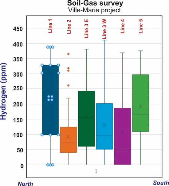
In Line 1, soil samples returned hydrogen concentrations between
150 to 300 parts per million (PPM), which is a relatively high
figure. This compares to exploratory efforts for a site in France’s
Pyrenees Mountains that uncovered under 100 PPM for 70 per cent of
its samples, while 70 per cent of QI Materials’ results range from
150 to 200 PPM.
From the August 15, 2024 news release:
Hydrogen Model
Professor Marc Richer Laflèche observes: "In
addition to bedrock lithological contrasts,
local Quaternary features may explain some
of the trends observed in the distribution
of soil hydrogen concentrations. For
example, MRNF drill data from the Line 1
sector (intersection of Route 101 and Chemin
du 4e Rang) indicate the presence of a 6 m
thick gravel unit above the bedrock. This is
overlain by 55 m of sandy-silty sediments of
glaciolacustrine origin (MacIntosh, 1973: GM
29616; SIGEOM). Thickness variations from
east to west of the gravelly unit (a more
permeable, porous and lenticular unit)
may
partially control the distribution of
hydrogen along Line 1." John Karagiannidis,
president of QIMC notes: "This will be
further verified by a geoelectric tomography
(ERT) survey in the fall of 2024 and by a
series of geotechnical boreholes in the
spring of 2025."
Sources of natural clean renewable
hydrogen at St-Bruno-de-Guigues
The geological map in Figure 2 shows the
local geology in the vicinity of Line 1 at
St-Bruno-de-Guigues. The volcanic belt of
the Baby Group, including 4 units of iron
formations (with extensions of the order of
10 km), basaltic tholeiites (iron-rich
amphibolites) and peridotites and komatiites
(ultramagnesian rocks), is perpendicular to
the graben and basins of Huronian (Cobalt Gp)
and Ordovician (New-Liskeard Gp) sedimentary
rocks (Richer-LaFlèche et al., 2020). "This
overlap implies the presence of Fe- and
Mg-rich Archean rocks beneath the
Proterozoic sedimentary rocks of the graben."
states Professor Marc Richer-Laflèche.
"Furthermore, this
interpretation is supported by MRNF
aeromagnetic data (SIGEOM interactive map),
which show a westward continuity of magnetic
anomalies originating from the magnetic
rocks of the Baby Gp. The presence of mafic
and ultramafic rocks that may contain
olivine relics and a high proportion of
amphiboles could explain the hydrogen
production." explains Professor
Marc Richer- Laflèche. "Note that during the
hydration process, H2O is reduced to H2 by
Fe2+-rich mafic and ultramafic minerals. On
the other hand, Cobalt Group arkosic
sandstones, which are particularly rich in
potassium and actinides, are ideal for the
production of radiolytic hydrogen. The
interaction of deep groundwater with these
rocks could produce radiolytic hydrogen.
This hydrogen could mix with hydrogen
produced by mineral hydrolysis."
QI Materials also has other hydrogen assets;
one in the Lac Saint-Jean region of central Quebec, and another in
the Gaspe Bay area;
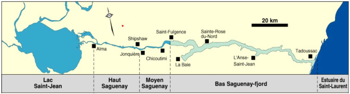
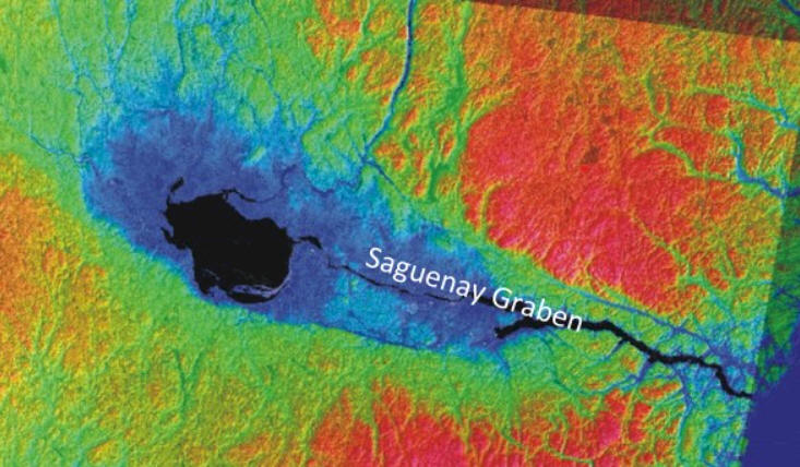
Figure 8. (above) -- A) Elevation map of
the Saquenay region and adjacent Precambrian terrains. B) Simplified
geological map of the Saguenay rift area. QIMC's exploration permits
are shown in red on the map.
"In addition to
taking into account the geological
characteristics that are critical for the
identification of exploration zones, QIMC
prioritizes sectors that are economically
favorable for the establishment of hydrogen
plants," said John Karagiannidis,
president of QIMC. "For
example, the strategic interest of the
Saguenay-Lac-St-Jean region is based on the
presence of a deep-water port infrastructure
at La Baie (Alma) (Figure 1). This would
make it possible to export hydrogen (solid
or gaseous) to European, Asian or American
markets bordering the Atlantic Ocean."
"The
Lac St-Jean hydrogen exploration project is
a logical continuation of QIMC's activities
in Quebec," said Prof Richer-Laflèche,
head of INRS' Applied Geoscience Laboratory.
"Based on the
compilation of geoscientific data and the
comparison of the geological context with
the Témiscamingue area," states Prof.
Richer-LaFlèche, "the Saguenay-Lac-St-Jean
area could be a second graben environment on
Precambrian basement, highly favorable for
the presence of white (natural) hydrogen."
"Geologically, the
project fits into the model of continental
grabens and rifts developed on Precambrian
basement with the essential characteristic
of being covered by Paleozoic sedimentary
rocks," continues Prof Richer-Lafleche.
"The NW-SE trending
Saguenay Graben cuts the Precambrian rocks
of the Grenville tectonic province over an
area of more than 300 km by 50 km between
the NW part of Saguenay-Lac-St-Jean (Albanel
sector) and Tadoussac. The graben is
associated with a large regional topographic
low, clearly visible on lidar or satellite
imagery, and locally associated with the
Saguenay Fjord (Fig. 2)."
"The
tectonic zone of the graben appears to have
been active since more than 546 Ma, as
evidenced by the emplacement of alkaline
magmatism represented regionally by numerous
carbonatites (e.g. St-Honoré carbonatite,
Niobec Mine), but also by lamprophyres and
kimberlites (Gittins et al., 1975)"
notes Prof Richer-Lafleche. "The
graben's normal faults were subsequently
reactivated between 200 and 250 Ma during
the Triassic and Early Jurassic (Tremblay et
al., 2013). The graben still exhibits
neotectonic activity, as evidenced by the
magnitude of the earthquake that struck the
Saguenay-Lac St-Jean region in 1988."
"In addition,"
states Professor Richer-Lafleche, "in
the western and southwestern parts of Lac
St-Jean, normal graben faults cut large
volumes of potassic granitic and syenitic
rocks, as well as mafic intrusive rocks
associated with the Lac St-Jean anorthositic
complex. Potassic rocks, which are also rich
in actinides, are potential sources for the
production of hydrogen by radiolytic
processes."
"The extensive
geological environment of the region is
ideal for hydrogen and helium exploration,"
said John Karagiannidis, president of QIMC.
"Our upcoming
natural hydrogen exploration program in Lac
St. Jean aligns perfectly with our mission
at QIMC to support Quebec's ambitious clean
energy and emissions reduction goals. By
advancing this program, we are not only
furthering our commitment to innovative and
sustainable energy solutions but also
contributing to the province's efforts to
achieve a greener and more sustainable
future. We look forward, as we did in Ville
Marie, to the positive impact our clean
hydrogen initiatives will have on the local
Lac St. Jean economy."
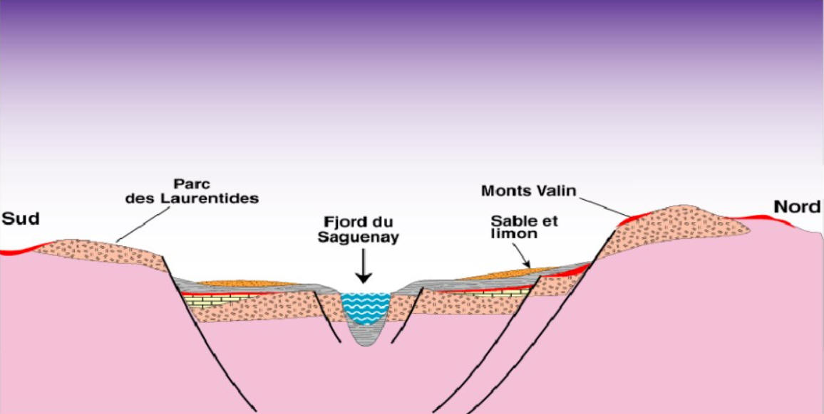
The schematic section in Figure 3 provides
an overview of the geology and topography of
the Saguenay Graben.
Gittins,J., Hewins, R.H., and∗,Laurin, A.F.,
1975. Kimberlitic-carbonatitic dikes of the
Saguenay River valley, Quebec,
Canada.Physics and Chemistry of the
Earth.Volume 9, pages 137-148.
Tremblay, A., Roden-Tice, M., Brandt, J.A.,
Megan, T.W., 2013. Mesozoic fault
reactivation along the St. Lawrence Rift
system, eastern Canada: Thermochronologic
evidence from apatite fission-track dating.
Bulletin of the Geological Society of
America 125(5-6):794-810.
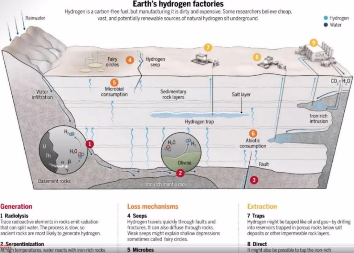
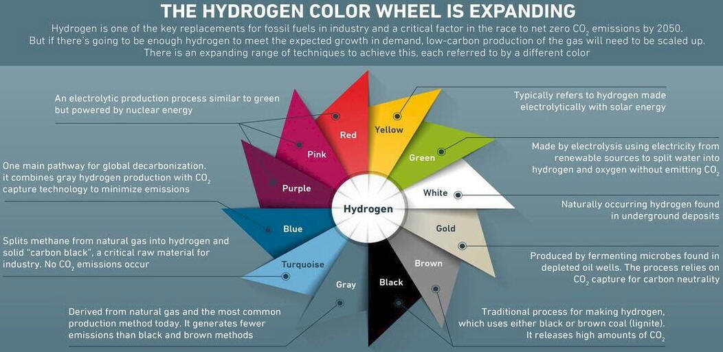
Natural Occurring (WHITE) Hydrogen is Superior and a
Relatively New Frontier in Exploration:
Figure 9. (above) The hydrogen rainbow
-- The current main production methods of hydrogen involve fossil
fuel, are environmentally
unfriendly, and subject to carbon capture. Green hydrogen (produced
using renewable electricity) is expensive. Natural occurring
hydrogen (a.k.a. white/gold hydrogen) is formed within the earth
via natural reactions of minerals at elevated temperature, also
via ionizing radiation within the earths crust,
continually flowing, with potential to provide
environmentally sustainable and affordable extraction in sizeable
volume where
favourable geological conditions exist.
View video that explores the exciting potential
of naturally occurring hydrogen gas trapped underground:
High-Grade Silica
Projects -- Valuable assets in
abeyance, awaiting production demand (once next-gen high-purity
silica technology applications come online).
QI Materials has an impressive portfolio of
high-grade SiO2 properties in Ontario and Quebec that it is able to
advance toward a near-term industrial mining production scenario
when market demand for high-purity silica comes of age. QI Materials
currently has a pilot silica processing plant, able to produce
custom products to meet prospective partners specification.
Current noteworthy partnerships:
HPQ Silicon Inc. ("HPQ"): MOU signed regarding the
procurement of Quartz from QI Material's Charlevoix Silica Project. Additionally, QI Materials has entered into a Right of First Refusal ("ROFR")
agreement with HPQ which allows HPQ the ROFR to purchase the first 10,000 tons of high-grade
silica material extracted from a QI Materials silica project.
Ekopav: MOU signed March 2023 regarding the procurement of
silica sands for production of asphalt products.
Next steps at key projects to be taken, once
clients indicate demand readiness:
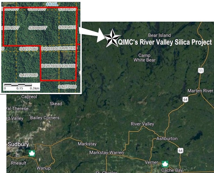
River Valley Silica Project, 65
Km northeast of Sudbury Ontario:
●
Perform mechanical stripping of the quartz vein formation.
● Perform a hybrid detailed exploration/geotechnical drill program in
order to delineate a resource and design the quarry.
● Execute
quarry design and production plan.
● Conduct advanced metallurgical
testing on silica material.
● Commence production permitting
process.
● Negotiate strategic offtake agreements.
Note: River Valley has no permitting issues, it
hosts a substantial quarryable body of 98% - 99.9+% pure SiO2
proximal roads and rail infrastructure.
Charlevoix Silica Project, Quebec:
● Secure bulk sample
permit for Zones 1 and 2.
● Perform mechanical stripping on newly
discovered zones 4, 5 and 6.
● Conduct exploration drilling on
newly discovered zones 4, 5, and 6 to evaluate the size, geometry,
depth, and width of the quartzite formation and determine if they
are continuously connected to one another.
● Negotiate strategic offtake agreements.
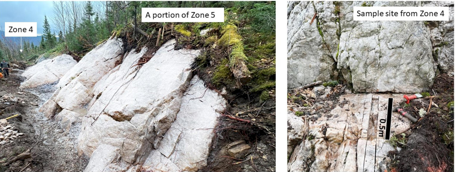
The new discovery zones at
Charlevoix are high-purity and are confirmed without permitting issues, 100% outside any
hunting & fishing zec. Property zones will be stripped clean and
various surveys conducted as needed with the intention of going
operational; so far zones 4 and
5 have been mapped in detail, cleaned off, channel sampled, and over
120m of strike length is now exposed at surface. The true thickness
and width of the quartzite formation is currently unknown as the
contacts are buried beneath overburden, however we can observe 5-10
metres high quartzite walls in certain areas.
On October-2023 QI Materials announced that it has
received a permit to further expand work on its high grade on
surface Charlevoix Silica Project. It was an 8 month process and
further expands the capacity to deliver even more high-grade
material. This permitting is in line with the Québec government’s
green supply chain strategy, and expands the QIMC’s operations and
ability to deliver even more high-grade silica to clients.
Demand for reliable high-purity quartz/silica feed is
increasingly critical for companies such as:
Major car manufacturers which
contemplating building new EV battery plants nearby (next gen
lithium silicon anode batteries offer improved performance and
capacity);
Solar
panel glass manufactures and a myriad of other applications
(ceramics, building materials, foundry and metals, coatings and
polymers, chemicals, filtration and absorbents, etc.).
WHY SILICA?
● Widely considered the next significant
advance in battery technology.
● Cost effective.
● Sustainable mining with inert materials.
● Little waste – Applications for all
grades.
● Most abundant element in earth’s crust
after oxygen.
● Growing Global silica sand market ($11.2B
in 2022 to ~$19B in 2029).
● New plants needed to meet demand growth.
Unlike traditional mining mineral resources
(such as gold), which require copious amounts of drilling, silicon
dioxide is industrial quartzite and a massive voluminous resource is
able to be blocked out quickly with a few 100m drill holes
(~1,000 m total should suffice), also these type of bodies are
typically operated for multiple decades and the grades/quality get
better with depth (where there is less weathering and impurities).
The hard part (which QIMC has already accomplished) is to find the
right combination of purity, consistency, access, permitting, and
infrastructure -- the actual extraction of material is typically
inexpensive (as its quarry-style mining), it is the transportation
costs that can quickly add up. At River Valley its a short trip down
the highway and onto established rail network, and at Charlevoix it is
only ~3.5 hours by road to Montreal (where HPQ, and other
manufacturers are along the Saint Lawrence). In-short, economics are
expected to be robust (once demand kicks in).
Figure 10. (above) -- QIMC has various grades
and types of feed stock, mined from its Charlevoix project, prepped
and ready for delivery to clients requiring silica according
to spec. Visible in the image above in the bags up front and
in the insets are large crystalline-like chunks that are milled to
specification; in HPQ Silicon Inc.'s case they are very specific:
X size, at X grade, X-sort of dimension,
roundness angularity, etc. -- reports are HPQ is very
pleased with the product being delivered and explains why HPQ
entered a ROFR agreement with QI
Materials. In the image above, any
weathered look is attributed to surface exposure -- simply crack
below the surface and the silica is much more translucent white. The
rows of bags further to the back are finer material, a by-product of
processing the main batch -- this material would go to a different
client such as an asphalt company; no waste.
Figure 11. (above) -- QIMC's pilot mobile
silica refining
processing plant for custom batches, with inset of current world market
pricing* (*annotated by Mining MarketWatch Journal). HPQ is able to take the feed from QIMC
and upgrade it using proprietary technology to US$500 - $5000/tonne
range product, HPQ can produce the value-added product significantly cheaper and more environmentally
friendly than any current process being employed now in the world.
Below is an summary of QIMC's key silica
assets:
1) River
Valley Silica Project - 100%-owned
Located in the Sudbury mining division, near
River Valley, Ontario, Canada
This project was recently acquired
September-2023 (click
here for related news release). This is a remarkably good project, news flow
should be steady from QIMC as it is quickly advances toward
large-scale operational quartz/silica quarry status.
Progress / Development Update on River
Valley:
See related October 24, 2023 news release "Qi
Materials Starts Preliminary Modelling of High-grade Silica Projects";
The QI Materials field team has completed the first pass of field
exploration and development work on the Company’s wholly owned River
Valley Silica project, located in the Sudbury mining division of
Ontario, Canada. The Company is now processing the data and
commencing preliminary modelling and quarry designs.
The following figures depict examples of the visually highly pure
quartz samples recovered from the quartz vein:
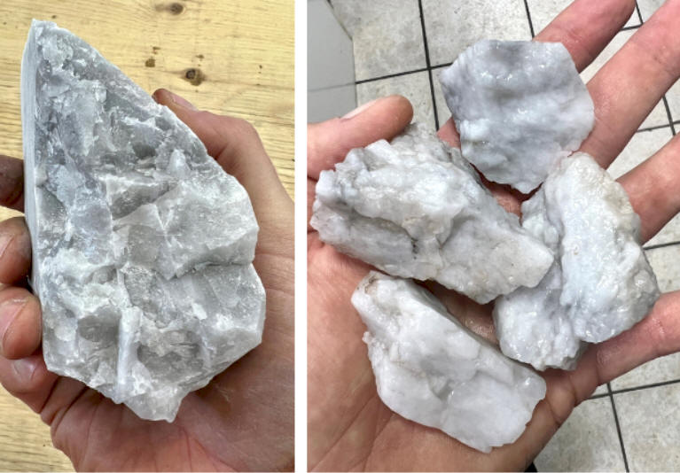
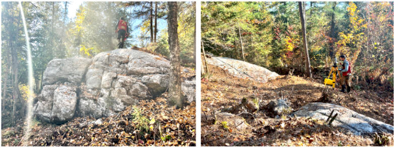
Figure 12. (above) - Visual high purity quartz
samples from River Valley Project quartz vein (source: October 24,
2023 corporate update news release).
Figure 13. (above) - Quartz
outcrops with technicians performing detailed
topographic survey (source: October 24, 2023 corporate
update news release).
The QI Materials team performed a variety of work scopes
in the advancement of this project which included:
Establishment of access
Detailed topographic survey of
the silica formation
Quartz outcrop stripping and
cleaning
Detailed geological mapping,
sampling, and channel sampling
Sample collection for
metallurgical and other analysis
Sample collection for testing
with the QI Materials’ pilot plant
The Company also performed a site visit with
the engineering team from OptiSim Mining Solutions, of Sudbury,
Ontario (See
news release Oct-11-2023) for the purpose of preliminary quarry
design, engineering, and permitting.
The River Valley Silica Project is host to a
high purity quartz vein. Publically available historical* purity
results and mapping indicate that the quartz vein is up 99.9% pure
SiO2. Historical* mapping indicates that the quartz vein is over
300m long and over 40m wide.
Figure 15. (above) Historical Results;
enlarged image of SiO2 section from lab assay table results from the
2019 report. Site visit by professional geologist Raymond Wladichuk,
CEO of Qi Materials, confirms that these historical reports appear
to be accurate;
Excerpt from December 12, 2023 news release "QI
Materials Confirms High Grade Silica Purity over 99.5% at the River
Valley Silica Project"; In October 2023, the QI Materials field
team collected roughly 75 channel samples from surface exposure. As
shown on the attached Table 1, 19 of the samples collected are over
99% pure SiO2, with the highest being 99.52% and, the average across
the sample set being 98.72% SiO2. It is expected that a degree of
contamination from surface contamination (surface water infiltrating
cracks and fractures, oxidation, and surface debris) is likely
affecting these results.
Figure 16. (above) Location Map of River
Valley Silica Property with inset claims map (different scale)
-- 65 kilometres north east (as the crow flies) from the world-class
mining camp of Sudbury, Ontario. It is easily accessed by existing
road infrastructure, and a short trip to the River Valley network of
rail transfer stations. The Property covers an area of approximately
47 hectares.
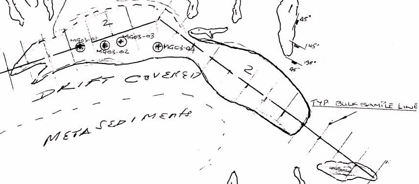
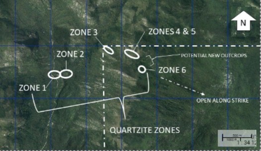
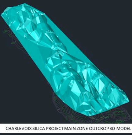
Figure 18. (above) Map of Charlevoix Silica
Project showing zones -- The new Zones 3, 4, 5, & 6 are
100% located outside the hunting and fishing zec, thus large-scale
permitting is no different than neighbour Sitec Mine, just across
the highway, which is the largest employer in this mining-friendly
region. Sitec quarries high-end quartz countertop material and has
operated for over 50 years.
Figure 19 a & b. (above) Aerial photograph of the
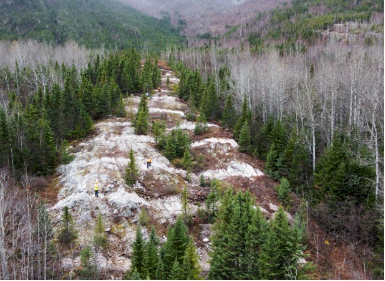
Charlevoix Silica Project Main Zone 1.
In the summer and fall of 2022, the Company
stripped the overburden off the Main Zone silica outcrop (Figure 1).
A series of 16 channels were cut across the stratigraphy and sampled
at one (1) metre long intervals as seen in Figure 2. Approximately
50% of the channel samples were sent to ALS Global for purity
analysis, the remaining samples were delivered to the Institute
National Research Scientifique (INRS) in Québec City for further
analysis. The results of the purity analysis suggest that the
majority of the Main Zone outcrop is comprised of high-grade silica,
returning an average grade of 98%, with purity ranging as high a
99.88% SiO2; see related April 26, 2023 news release entitled "QI
Materials Reports High-Grade Results from Channel Sampling".
New Zones (3, 4, 5, & 6) on Charlevoix
Silica Project
See related August 29, 2023 news release "QI
Materials Announces Assays over 99% SiO2 from Newly Discovered Zones
at the Charlevoix Silica Project"; The QI Materials field team's
mapping and prospecting efforts have led to the discovery of newly
found quartzite outcroppings with remarkably high purity grade. The
new zones currently named zones 3, 4, and 5 occur approximately one
kilometre northeast of zones 1 and 2. According to SIGEOM, the
ministry of Quebec's public natural resources database, the new
zones are located outside of the Zec des MartresSeven (7) samples
were delivered to ALS Global's lab in Val d'Or, Québec where they
underwent purity analysis. These samples were selected from various
locations on the outcrops and averaged over 98% SiO2 ranging from
97% to over 99%:
SAMPLE
%
SiO2
%
Al2O3
%
Fe2O3
%
CaO
%
MgO
%
Na2O
%
LOI
%
Total
X370201
97.95
0.76
0.66
0.02
0.05
0.02
0.21
99.81
X370202
97.04
1.19
0.52
0.02
0.04
0.16
-0.02
99.74
X370203
98.12
0.50
0.70
<0.01
<0.01
<0.01
-0.09
99.43
X370204
98.52
0.54
0.87
<0.01
<0.01
0.01
0.04
100.05
X370205
97.56
0.97
0.83
0.03
0.08
0.20
-0.05
100.10
X370206
98.76
0.25
0.65
<0.01
0.01
<0.01
-0.08
99.74
X370207
99.07
0.16
0.66
<0.01
<0.01
<0.01
-0.06
99.89
Table 1. (above) Assay results from new
zones.
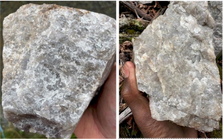
Figure 20a&b. (above) Photos of Quartzite
Samples from New Zone --
The majority of the samples collected from the new zones are of
beautiful, clear, near-crystalline quartzite.
Figure 21 a & b.
(above)
Photos of quartzite from zone 4 & 5
Figure 22. a (above)
Vertical wall of quartzite, new zone
Charlevoix
Figure 22. b
Quartzite, new zone Charlevoix
Figure 23.
Translucent quartzite, new zone Charlevoix
Figure 24.
Photos of a portion of zone 6 quartzite
outcrop
Progress / Update on Charlevoix:
See related October 24, 2023 news release "Qi
Materials Starts Preliminary Modelling of High-grade Silica Projects";
The QI Materials team is currently at the Charlevoix Silica Project
completing the final field work of the season. The team is following
up on the newly discovered high grade zones announced in August 2023
(See
news release). The scope of this program includes:
Establishing access to the new
high-grade zones
Detailed geological mapping and
sampling
Quartzite outcrop stripping and
cleaning
Channel sampling
Exploration and prospecting to
trace out the surface expression of the quartzite
formation
Sample collection for
metallurgical and other analysis
Sample collection for testing
with the QI Materals’ pilot plant
QI
Materials Update on Roncevaux Silica
Property Exploration
Lachute, Québec--(Newsfile
Corp. - January 10, 2024) - Québec
Innovative Materials Corp. (CSE: QIMC) (FSE:
7FJ) ("QI Materials", "QIMC", or the
"Company") provides an update on the
Roncevaux Silica Property.
As disclosed in the Company's August 31,
2022 news release, Qi Materials acquired
mineral claims from HPQ Silicon Inc. (HPQ"),
including the Roncevaux Silica Property. The
Qi Materials team performed a recent site
visit to the property in late October 2023.
"We would like to
thank our partner HPQ for this opportunity
to further develop this asset and meet their
growing high grade silica demand,"
stated John Karagiannidis, Executive
Chairman.
Roncevaux Silica Property
The Ronceveux Silica Property consists of a
high purity quartz vein located in southern
Quebec, approximately 50km from Amqui,
Quebec, as shown on Figure 1. The property
consists of 27 mineral claims totalling 1570
hectares. Samples were collected by means of
existing trenches found on the property. The
quartz vein is estimated to potentially be
over 300m long with the width being unknown
but likely 10's of metres wide (as suggested
by historical work and reports).
"We believe this is
another significant addition to our growing
high grade silica Quebec portfolio,"
stated Raymond Wladichuk, CEO.
Historical work conducted by HPQ Silicon
Inc. indicates that the purity of the quartz
vein is as high as 99.8% SiO2. HPQ conducted
testing on the quartz material from this
property and concluded that it was able to
be converted to silicon metal by means of
their patented processes.
The recent samples collected by the Qi
Materials field team indicate that visually,
this appears to be accurate (Photos in
Figure 2 below). Tens of kilograms of
samples have been collected for testing and
analysis by the Company.
The author of one of
the historical reports acquired by means of
SIGEOM (the Quebec government's publicly
available geoscience database) provides an
estimated tonnage of over 400,000 tonnes of
quartz material (if extrapolated to a depth
of 50m) (this is a non-43-101 compliant
estimate and extracted from publically
available data such as historical assessment
reports, prospecting reports, etc.).
Please be advised that a qualified person
has not completed sufficient work to
classify any mineral resources as defined by
National Instrument (NI) 43-101; it is
therefore uncertain if future exploration
will result in the delineation of mineral
resources. ...
Québec
Innovative Materials'
Management, and Governance Skip to top
The current management team and board of directors has a
well rounded combination of people that each contribute
expertise in disciplines necessary for a successful
mining entity:
John Karagiannidis, MBA, LL.B – President, CEO, and Director
Mr. Karagiannidis was born and raised in Montréal,
Québec, and has been involved in over 300 transactions
involving emerging private and public companies with a
total value in excess of $2 billion. Mr. Karagiannidis
is currently a dealing representative at EMD Financial.
Prior to EMD Mr. Karagiannidis worked at Marquest
Capital Markets, Industrial Alliance Securities, and
Desjardins Securities. Mr. Karagiannidis is an MBA
graduate of the Ivey Business School (University of
Western Ontario), LL.B from the University of Montréal
and is a member of the Québec Bar Association.
Richer-LaFlèche, P.Geo - Advisor
M. Richer-LaFlèche. is a professional geologist
registered with the Ordre des géologues du Québec a also
holds an FRQNT grant, in partnership with Quebec MRN and
the mining industry. Mr Richer-LaFlèche is an associate
professor and Scientific Head of the Applied Geosiences
Laboratory at Instutute National de la Recherche
Scientifique (INRS)
Marianne Richer-LaFlèche, - Director
Ms. Richer-Laflèche is a lawyer at BCF Montréal office,
where she specializes in mergers and acquisitions,
investment funds, corporate governance and commercial
contract drafting. Prior to joining BCF, Ms.
RicherLaflèche worked at another major Canadian law
firm, where she was seconded on two occasions to clients
in the financial services and consulting engineering
sectors. Ms. Richer-Laflèche is a graduate of Université
Laval. She has acted as director and corporate secretary
for several organizations, including the Fondation du
Collège JésusMarie de Sillery, Prima Danse Events,
Théâtre Lirychorégra 20 and is currently a member of the
board of directors of the École des entrepreneurs du
Québec
.
Jakson Inwentash, B.Comm, CFA– Chairman, Director
Director & VP at ThreeD Capital,
Inc., Independent Director at SLAM Exploration Ltd.,
Director and VP of Investments at Threed Capital,
Inc., Director at KOP Therapeutics Corp., Independent Director at First Tidal Acquisition Corp.,
Director at Nirvana Life Sciences, Inc., and Advisor at Better Bears Foods, Inc. and DeFi Yield
Technologies, Inc. He previously served as the Director
at Bluesky Digital Assets Corp. from 2021 to 2022 and as
the Director at Gratomic, Inc. from 2019 to 2020. Mr.
Inwentash obtained his undergraduate degree from the
University of Miami in 2016.
Lisa Thompson – Director
Lisa Thompson brings over 20 years of experience as a
corporate/securities paralegal, working with both large
and small public companies listed for trading on US and
Canadian stock exchanges. For the past 5 years, Ms.
Thompson has provided corporate secretarial consulting
services for US and Canadian companies. Lisa has also
served on various non-profit boards and committees and
is a member of the BC Paralegal Association. She is a
co-founder of Meraki Corporate Services in Vancouver,
BC.
Hani Zabaneh – Director
Mr. Zabaneh is a seasoned consultant specializing in
growth funding, mergers, and acquisitions, and
transitioning companies to public markets. For over 20
years, Mr. Zabaneh has held both officer and board
positions in numerous public companies including Summa
Silver Corp., Blue Gold Mining, Auryn Resources, and
Sigma Lithium Resources Corporation. Mr. Zabaneh
currently serves on several boards of public companies.
Previously, Mr. Zabaneh was a principal at Orange
Capital Corp, a boutique investment bank located in
Vancouver, BC. He was also Vice President of Corporate
Development at Eventbase Technology Inc., where he was
instrumental in helping the company secure Series A
financing from a US-based VC.
Ming Jang, CPA, CGA – Director, CFO
Ming Jang is a professional accountant with over 25
years of experience in senior financial management roles
across various sectors, including mining, nonprofit
organizations, and the medical wellness industry. He has
successfully executed several companies public listings,
including Numinus Wellness Inc. and most recently,
Adaptogenics Health Corp. Mr. Jang currently serves as a
financial consultant to various private and publicly
listed companies, providing robust financial management
and oversight in the structuring and implementation of
financial and regulatory processes.
Note: This article is not intended to be a complete overview of
Québec Innovative Materials Corp. or a complete listing of Québec
Innovative Materials'
projects. Mining MarketWatch urges the reader to contact the subject company and has
identified the following sources for information:
For more
information contact Québec Innovative Materials head office at:
PH
+1-514-358-8840
We provide insight into resource
companies, many which are so often overlooked gems and can provide
exceptional potential to richly reward investors. The
companies we select offer outstanding properties, management and
experience in the mining/exploration industry.
Sector NewswireTM
*Content found herein is not investment advice
see Terms of Use, Disclosure & Disclaimer.
This is a journalistic article and the author is not a registered securities
advisor, and opinions expressed should not be considered as investment
advice to buy or sell securities, but rather journalistic opinion only.
Technical mining terms used by the writer may be used/expressed in simplified layman
terms and should not be relied upon as appropriate for making investment
decisions unless the reader contacts the company directly for independent
verification. *Estimates of potential made by the mining analyst and
journal(s) are non 43-101 and not from the Company.


 CSE:QIMC presents exceptional value and could easily move to be
trading, in the near-term, several multiples higher than its current
share price:
QIMC currently has a nominal market cap of only ~C$25M (~107
million shares trading near ~C$0.23). Over 50% of the shares
outstanding are held by insiders and family. Although QIMC's high-purity
silica assets are valuable on their own, it is on the
hydrogen front that QI Materials could see extraordinary near-term
gains. The shares outstanding quoted above include the recent
announcement of 9.915 million warrants having been exercised, which
also leaves the Company sufficient funds to accomplish natural hydrogen
exploration goals well into Q2-2025. The Québec government has an ambitious goal of reducing GHG
emissions by 37.5% from 1990 levels by 2030, the role of green
hydrogen initiatives feature prominently in its strategic plan.
CSE:QIMC presents exceptional value and could easily move to be
trading, in the near-term, several multiples higher than its current
share price:
QIMC currently has a nominal market cap of only ~C$25M (~107
million shares trading near ~C$0.23). Over 50% of the shares
outstanding are held by insiders and family. Although QIMC's high-purity
silica assets are valuable on their own, it is on the
hydrogen front that QI Materials could see extraordinary near-term
gains. The shares outstanding quoted above include the recent
announcement of 9.915 million warrants having been exercised, which
also leaves the Company sufficient funds to accomplish natural hydrogen
exploration goals well into Q2-2025. The Québec government has an ambitious goal of reducing GHG
emissions by 37.5% from 1990 levels by 2030, the role of green
hydrogen initiatives feature prominently in its strategic plan.  A good comparable
for investors in QI Materials to look at is
A good comparable
for investors in QI Materials to look at is

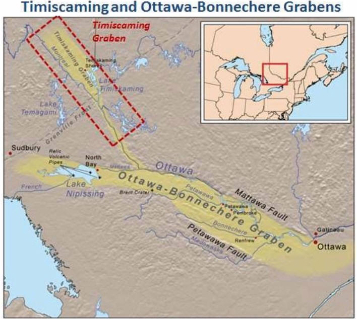
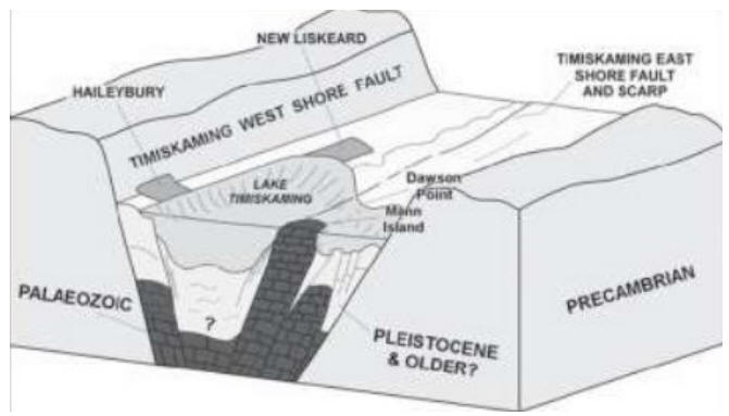
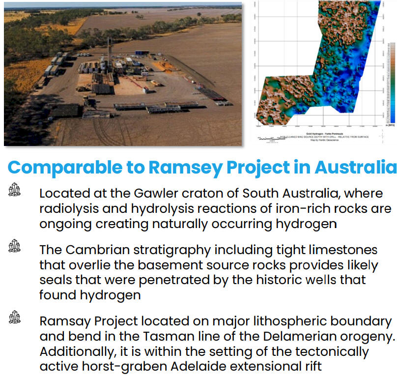 Fig. 5b (left) Comparable
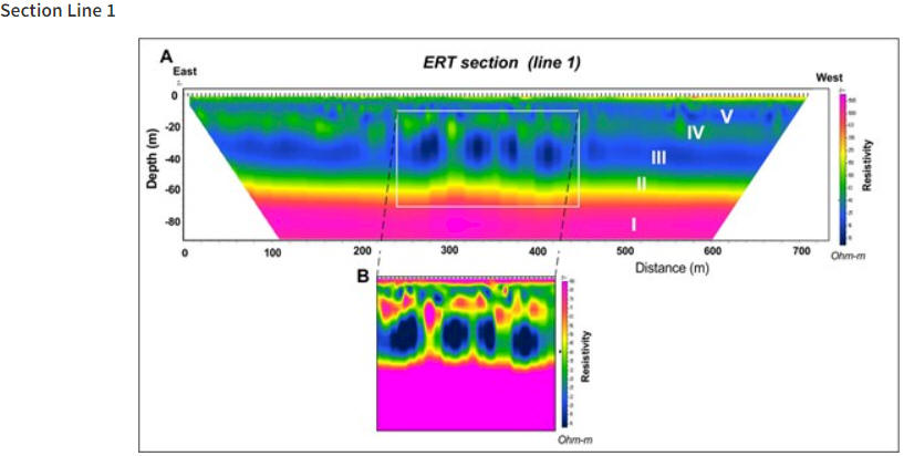


